Published November 6, 2026 · Taken Social Editorial
NASA's Artemis II flight is back in the news for something it left behind on the way to the Moon: disturbances in the electrically charged upper atmosphere through which satellite navigation signals travel. The renewed attention concerns research into the April mission, rather than a new launch in November.
The finding has an immediate appeal because GPS underpins so much ordinary activity. A phone finding a street, a surveyor locating a boundary and an aircraft using satellite navigation all depend on signals arriving through an atmosphere that is constantly changing. A powerful rocket adds another event for researchers to measure in that environment.
The important question is how a measured atmospheric disturbance translates into the performance of an actual navigation system. The observations and the possible engineering consequences belong in the same discussion, but they are different kinds of evidence. A change detected by scientific receivers does not by itself establish that a car changed lanes, a drone lost control or the public GPS service failed.
That distinction makes the Artemis II story more useful, not less interesting. It points to a research problem that can be investigated: where rocket-related disturbances occur, how long they persist and which receivers can compensate for them.
What brought Artemis II back into the headlines
In an interview published by Space.com on November 4, National Cheng Kung University earth scientist Charles Lin described research into the mission's effects on the ionosphere. The work used fixed, ground-based GPS observations to investigate changes in electron content associated with the rocket's passage and subsequent maneuvers.
Lin discussed possible implications for precision navigation, including drones and automated vehicles. His comments concern the consequences that sufficiently large positioning errors could have. They do not document an autonomous vehicle incident caused by Artemis II. The distinction between a potential application risk and an observed failure is central to understanding the news.
The work is identified as a preprint, titled Rare reoccurring ionosphere disturbances observed during the Artemis-II Lunar flyby voyage, with a July 22 posting date. A preprint record is a route for sharing research before completed peer review; it should not be presented as proof that a journal has independently validated every result.
NASA's mission record supplies the essential calendar. Artemis II launched April 1, 2026, and splashed down April 10 after nine days, one hour and thirty-two minutes. Reid Wiseman, Victor Glover, Christina Koch and Jeremy Hansen flew aboard Orion on a crewed lunar flyby.
The flight was a major test of systems needed for human exploration beyond Earth orbit. Its launch vehicle, the Space Launch System, combined solid rocket boosters with a liquid-fueled central stage. The mission's success and the study of its atmospheric footprint address different questions: whether the spacecraft and crew completed their flight, and what effects the launch and maneuvers produced along the way.
That is why a November science story can legitimately concern an April flight. Space missions produce observations that take months to process and interpret. A later analysis can reveal something that was not apparent in the live coverage of liftoff.
NASA's preliminary lunar science report provides another example of that process. It records the crew's observations of Earth, including lightning, auroral motion, city lights and airglow. Those observations concern what the astronauts could see from Orion. They complement the mission record but are distinct from a ground-based investigation of the ionosphere using satellite signals.
The ionosphere is part of the navigation system
The ionosphere contains electrically charged particles that affect radio propagation. Satellite navigation signals must pass through it on their way to receivers on the ground. Changes in that medium can alter the travel time used to calculate a position.
NOAA's explanation of total electron content, usually shortened to TEC, describes why scientists monitor the quantity. It represents electrons along a signal path and is useful for evaluating possible impacts on satellite communications and navigation. The relevant quantity is not simply whether a rocket is visible overhead, but what the signal encounters between satellite and receiver.
For a receiver estimating distance from signal timing, an uncorrected propagation delay can become a distance error. Measurements of the ionosphere consequently matter even when the navigation satellites themselves are operating normally. A system can face a difficult transmission environment without a satellite breaking down.
NOAA also describes models used to reduce ionospheric error in single-frequency GPS. Such corrections mean that a raw atmospheric change cannot automatically be equated with the final error shown on every user's device. Receiver design and the corrections available to it affect the result.
The National Weather Service's space weather training material explains how networks of dual-frequency receivers can be used to construct electron-content maps. This creates an important dual role for navigation signals: they provide positions, but scientists can also use their behavior to investigate the medium through which they travel.
That helps explain why fixed scientific stations are valuable. Their known locations provide a stable reference for examining signal changes. A research measurement made in that setting can identify a phenomenon that deserves engineering attention, while a separate analysis is needed to establish how a moving consumer or professional receiver responded.
What a rocket-related atmospheric “hole” means
The word hole is vivid, but in this context it refers to a region of reduced electron density. It is not an opening through which the atmosphere disappears into space. Researchers are studying changes in an ionized medium, rather than a missing piece of the sky.
A 2020 research paper on rocket-induced ionospheric depletion describes how exhaust chemistry and atmospheric transport can produce and then modify such regions. The authors modeled the processes using a general circulation model and discussed implications for radio communication and navigation signals.
The chemistry provides a reason to examine more than the force of liftoff. Where exhaust is deposited, how it spreads and how the surrounding atmosphere evolves can all matter. The same paper describes recovery as the exhaust gases disperse and the rate of electron loss declines.
A separate 2026 study of a Long March 2D launch investigated the three-dimensional development of an electron-density depletion. Its reported altitude range and changing timing with height illustrate why a single dramatic number cannot describe every aspect of an event. Different parts of a disturbed region can evolve at different times.
Those studies are background, not measurements of the Artemis II flight. Their relevance is that rocket-related ionospheric changes are an established subject of investigation. The new mission offers a particular set of launch conditions and maneuvers to examine within that broader field.
Separating the background mechanism from the new observation also prevents an exaggerated claim of discovery. Researchers can already know that rockets disturb the ionosphere while still learning something new about the scale, sequence or geometry of a particular mission's effects.
Why the impact depends on the receiver
The Canadian government's space weather technology guidance explains that dual-frequency GPS can, under some conditions, compensate for much of the ionospheric propagation delay by comparing signals at different frequencies. That qualification matters: mitigation is possible, but performance depends on the conditions and the system.
A large change in a scientific data product therefore does not imply the same error across a phone, an aviation receiver and a specialized survey instrument. Each may process signals differently and use different sources of correction. The correct comparison is between the disturbance and the requirements of a defined application.
The Federal Aviation Administration's space weather program treats the ionosphere as an operational concern because aircraft navigation and communications depend on signals passing through it. Its work addresses the reliability of the aviation system, rather than assuming every atmospheric disturbance produces an accident.
For any claim about a real-world impact, several details would be useful: the time and location of the receiver, which signals it used, the corrections available and its performance relative to an independent reference. Those are the observations needed to move from an atmospheric measurement to an assessment of an actual user's positioning error.
The same reasoning applies to automated vehicles. A statement about the consequences of a positioning error is not a complete account of how a vehicle's navigation system would behave. Demonstrating that connection would require evidence from the relevant system under the relevant conditions.
The next scientific question is measurable
Artemis II's atmospheric wake deserves attention because it connects two growing technical activities: powerful spaceflight and increasingly precise navigation on Earth. The useful response is to improve observations and test the connection between them, with enough detail to distinguish temporary signal effects from service disruption.
Future studies can compare launch events with background conditions, align atmospheric measurements with engine activity and examine how different receivers handled the same interval. Reproducible timing, transparent methods and comparisons across instruments would make the results more valuable to both scientists and operators.
For readers, the current conclusion is narrower than the most alarming headlines. Researchers are investigating disturbances associated with April's lunar mission and discussing their potential navigation implications. That is consequential science. It does not establish a newly confirmed public GPS outage or a documented autonomous-driving incident in November.
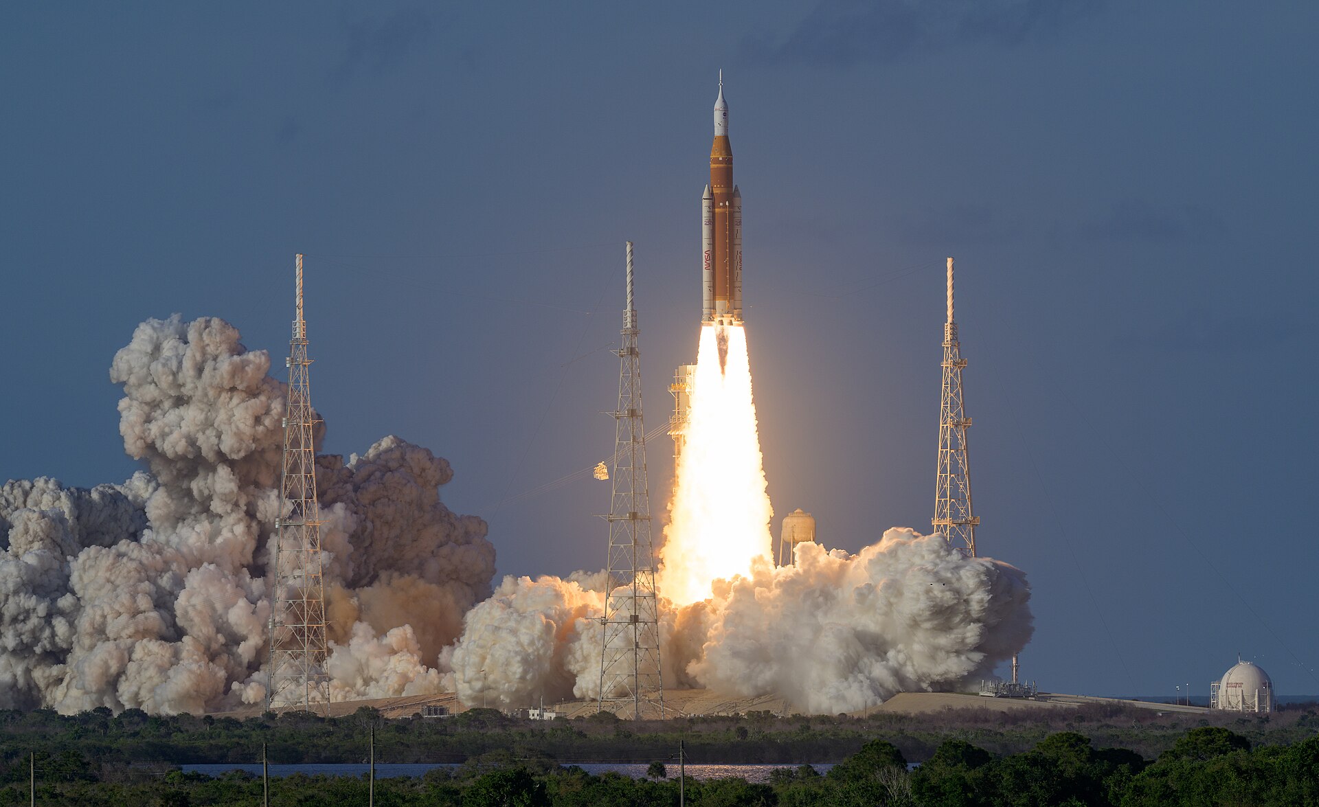
NASA’s Space Launch System rocket carrying the Artemis II crew lifts off from Kennedy Space Center on April 1, 2026. Photograph by NASA/Bill Ingalls; public domain. This is an authentic image of the April mission discussed in the atmospheric research. Source: Wikimedia Commons.